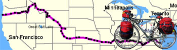
Today's Miles = 94.3
Average Speed = 10.3 mph
Maximum Speed = 25.1 mph
Total Miles = 3830.8
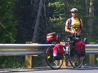 My hidden spot served me well through the night and I slept undisturbed until the break of day. In the morning however, the clearing that I had chosen as a good place to rest was also chosen by a pair of fishermen as a good place to park their truck. Even though they ended up standing not ten yards away from me they didn't spot my tent through the trees and brush, and they shared a pipe and joked with each other before hiking off with their fly rods over their shoulders.
Up and packed not long after sunrise, I thought that this would be a good day to make some big miles. I was camped at an elevation of around 3,000 feet and would be slowly descending to 1,000 feet over the next 70 miles. The ride was almost effortless as I spent hour after hour descending down a river canyon that could make the most tumultuous soul feel tranquil.
My day passed peacefully all the way to the town of Kooskia, whereupon I had to begin my climb up White Bird Mountain. Back in Jackson I had asked some eastbound riders what their hardest climb to date had been, and the rolled their eyes and said "Old White Bird". White Bird rises nearly 3,000 feet from the valleys that surround it, and for eastbound riders this climb is compressed into a ten mile stretch of road. Fortunately the approach for westbounders is more gradual, as I would have thirty-five miles of riding interrupted by an overnight stay to make the same climb. As I threw myself into the afternoon's climb, my mind formed an explanation of what I am finding the difference between the hills in the east and the hills in the west to be. Here in the west the hills require long periods of hard effort, but in the east the hills required short periods of impossible effort. While both are difficult, it isn't easy to compare riding ten miles up a 7% grade to riding one mile up a 12% grade.
It had been hot and humid for hours, and as I began the climb up the foot of White Bird the clouds that had gathered overhead finally began to unleash the rain they contained within. Donning my rain gear and returning to the climb, I had a funny thought. Here I am covered with sweat beneath my clothes, rain pouring into my face and blocking my vision, forcing myself to climb higher and higher up this mountain, and it just feels wonderful to be alive.
 After a couple thousand feet of climbing I have to admit I wasn't feeling quite so wonderful. I hadn't done a good job keeping my body fueled during the day, and as I started to near Grangeville my body began to run out of gas. It isn't always easy for me to tell when my blood sugar is flagging as one of the first thing that it effects is my mind. My thinking starts to get cloudy and my reasoning less clear. Sometimes the first sign I'll have that I'm having a problem is when I start to struggle to do the mental addition and subtraction to figure out how many miles I have left to go, but if I'm not paying attention I'll just get frustrated instead of understanding what is happening.
With about an hour of climbing left I somehow got the clarity of mind to ask myself how I was doing. My thoughts were a fog and when I held my hand in front of my face it wouldn't stay steady. It was time to take a break and stoke the fires with some fresh sugar and fat. I pulled my second-to-last candy bar from my panniers and followed it up by eating spoons of peanut butter until I felt my energy starting to return.
I had company on the mountainside of a Harley rider who had stopped to enjoy the view. By coincidence he was from Estes Park, just outside of Fort Collins, and we talked about home and about our trips so far. Since I started riding I've been happy to share the road with motorcyclists, particularly those touring on Harleys. The traveling motorcyclists consistently go out of their way to pass me safely, and I almost always get a friendly wave as they ride by. Truck and automobile drivers seem often to resent having to share the road with anyone with less than four wheels, and I think that because motorcyclists feel the brunt of this resentment they also feel a sympathy towards those of us on two wheels who don't have an engine from Milwaukee helping us along.
When I got to Grangeville I really wanted a motel room, and was sorely tempted to check into the cheapest one I could find. The call of a bed was tempting and I wanted very much to find a place where I could connect my computer so I could communicate with the "outside world" once again. But as much as I craved the comfort, it would have just been throwing money away. It was nearly 10:30 in the evening and too late to have enough time in a room to justify the expense. Instead, it was the city park for me, along with a promise to make tomorrow a short day and find a room in the early afternoon.
I was one of those fishing guys a couple of times on that stretch of road. If Luis and Clark only had a bike and a fly rod, the Lolo pass would have been perfact. By the way, fishing there is damn good. Especially for cuthroats. We caught more on that stretch than at the Big Hole. It's also cool to know that the river is the norther border of the Frank Church River of No Return Wilderness. I believe it to be the biggest in the lower 48. Big enough to produce rumors and USFS warnings of Grizzly migrating back into the area, but as of 4 years ago, knowbody had seen one.
Nick,
I am not sure how often you are able to check this site or how close you are to Sisters, Oregon but....
I was out there yesterday and there is a pretty bad wildfire in the area. The whole valley around that area was smoky and they even closed Hwy 20 to Sisters for a while. I wouldn't envy you having to ride through that smoke! So, if you do find that the area is still on fire, there may be another option. Definately try to go up through Sisters because the Mackenzie Hwy is fabulous. But, if that is looking bad you can head south on hwy 97 to Bend and then take the Cascade Lakes Hwy to Hwy 58 that will take you to Eugene. The Cascade Lakes Hwy is gorgeous. You should probably do a little more research about this option if the Sisters direction is looking bad.
J.O. Price
Portland, Oregon